
A topographical survey is vital for accurately understanding land, as it maps natural and man-made features, including contours, elevations, and boundaries. Did you know 77% of private construction projects depend on topographic surveys to ensure proper planning and development? If you’re wondering, “What is a topographical survey?” it’s a detailed process used to assess the land’s terrain and provide crucial data for planning any project—from construction to property boundary resolutions. Steve Daria and Joleigh, renowned real estate investors and land buyers for cash, have helped countless property owners benefit from topographic surveys. They stress the importance of these assessments in making smarter, more informed decisions about land use. Now is the time to find out “What is a topographical survey?” and how it can serve your needs. Book a free discussion with Steve and Joleigh today to explore the full potential of your property!
Key Points
- Purpose of Topographical Surveys: A topographical survey maps out the physical features of a piece of land. It includes elevations, contours, boundaries, and any existing structures to help understand the terrain better.
- Data Collection Process: These surveys use advanced tools like GPS, laser scanners, and theodolites to measure and record land details accurately. Surveyors also analyze the land’s natural and man-made features to produce detailed reports and maps.
- Importance in Projects: Topographical surveys are essential for construction, land development, and resolving boundary disputes. They provide critical data to ensure the project is planned and executed correctly, avoiding costly mistakes.
- Key Beneficiaries: Engineers, architects, builders, and property investors often rely on these surveys before starting a project. They help visualize potential design issues and adjust plans based on reliable terrain data.
- Compliance and Legal Use: To meet regulations, topographical surveys are often required for legal and zoning purposes. They also provide proof of property boundaries and land features for accurate documentation and dispute resolution.
What is a topographical survey, and why is it important?
A topographical survey is a method used to collect and measure detailed information about the physical features of a specific piece of land.
It helps map out both natural elements, like hills, trees, and rivers, and man-made features, such as buildings, fences, and roads.
If you’ve ever wondered, “What is a topographical survey?” it’s essentially a tool that provides a clear picture of the land’s surface, including elevations and contours.
This detailed information is vital for planning projects because it ensures that all aspects of the land are considered.
For example, architects and engineers use it to design buildings that fit well with the terrain, avoiding costly mistakes.
It’s also crucial for resolving property boundary disputes and ensuring legal compliance during construction.
Without a topographical survey, you might overlook key details that could lead to errors or delays.
By using this survey, you gain accurate data to make smarter decisions for any land-related project.
Whether you’re building, buying, or developing, understanding the land’s layout is essential!
Get Started: Get Your Cash Offer Below…
We are direct land buyers. There are no commissions or fees and no obligation whatsoever. Start below by sharing where your property is and where we can send your offer…
Who needs a topographical survey?
A topographical survey is essential for anyone who needs a detailed understanding of a piece of land and its physical features.
If you’re wondering, “What is a topographical survey?” it’s a professional process that maps natural and man-made elements such as elevations, hills, buildings, and boundaries.
Homeowners planning renovations or extensions may need this survey to ensure their designs fit the terrain safely.
Architects and engineers rely on topographical surveys to create accurate blueprints that align with the land’s unique landscape.
Before starting a project, builders and developers use it to identify potential challenges, such as uneven ground or drainage issues.
Property investors can benefit from these surveys to understand the full potential and limitations of the land they are purchasing.
Even legal professionals might require this data to resolve disputes over property boundaries.
Overall, anyone involved in buying, developing, or modifying land will find a topographical survey invaluable for making informed decisions.
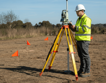
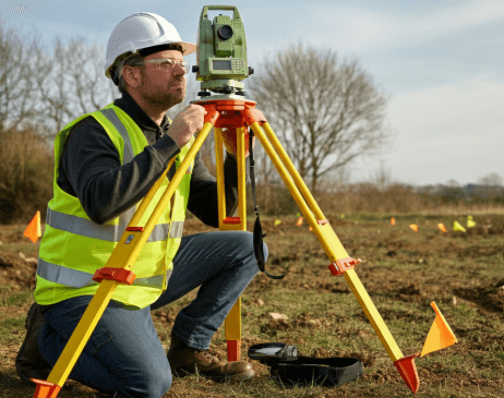
What tools are used in topographical surveys?
- GPS (Global Positioning System): GPS devices help surveyors accurately find precise locations on the land. They are an essential tool in answering the question, “What is a topographical survey?” by providing reliable data on distances and elevations.
- Total Station: A total station combines tools to measure angles and distances into one device. It’s critical for mapping land features and boundaries, which is key in making a topographical survey detailed and accurate.
- Laser Scanners: Laser scanners collect vast amounts of data to create detailed 3D models of the land. These devices make it easier to understand elevations and terrain, showing how “What is a topographical survey?” involves advanced tools for precision.
- Drones with Cameras or LiDAR Sensors: Drones capture aerial photos and topographical data, especially in larger or hard-to-reach areas. This technology speeds up surveys while maintaining high accuracy.
- Leveling Instruments: These tools measure differences in elevation to map out the contours of the land. They help answer the question, “What is a topographical survey?” by showing the vertical distances necessary for creating accurate terrain maps.
How accurate are topographical surveys?
Topographical surveys are highly accurate because they rely on advanced tools and techniques.
These surveys measure land features, elevations, and boundaries with precision, ensuring that the data collected is reliable for any project.
When asking, “What is a topographical survey?” it’s important to understand that it’s a process designed to gather the most detailed and accurate information about a specific piece of land.
The accuracy of a survey often depends on the equipment used, such as GPS systems, total stations, or drones with LiDAR sensors.
Surveyors also follow strict methods and standards to reduce errors, making the results dependable.
However, the scale of the survey and the terrain’s complexity can slightly affect the level of precision.
For example, rough or wooded areas might cause minor challenges in collecting data.
Overall, topographical surveys provide a detailed and trustworthy representation of the land, which is why they are crucial for planning and construction projects.
How do I choose a surveyor for a topographical survey?
1. Verify Their Qualifications and Licenses
Ensure the surveyor you choose is licensed to practice and has the proper certifications in land surveying.
Professionals with the right credentials are trained to handle detailed surveys with accuracy and expertise.
If you’re wondering, “What is a topographical survey?” it’s a specialized process that measures land features, and only a qualified surveyor can ensure reliable results.
2. Look Into Their Experience
Choose a surveyor with plenty of experience conducting topographical surveys, especially in your region.
An experienced surveyor will know how to handle different terrains and adapt to challenges such as uneven ground or heavily wooded areas.
Knowing “What is a topographical survey?” helps you understand why their expertise is vital for gathering accurate land data.
3. Check Their Tools and Technology
Ask about the surveyor’s equipment, such as GPS, total stations, and drones.
Advanced tools not only make the job faster but also improve the precision of the survey.
The right technology is essential for creating a detailed map of your property that meets your needs.
4. Read Client Reviews and Ask for References
Review reviews and client testimonials to learn about the surveyor’s reliability and professionalism.
Consider requesting references to gain firsthand insights from those who have previously collaborated with them.
Positive feedback will give you confidence that you’re hiring the right person for the job.
5. Discuss Costs and Timelines Clearly
Before hiring, discuss the surveyor’s fees and how long they expect the project to take.
By having everything agreed upon in writing, you can ensure there are no hidden costs or delays.
Clear communication upfront ensures a smooth process and avoids surprises later on.
How do I get started with a topographical survey?
To get started with a topographical survey, the first step is to identify the purpose of the survey and the specific details you need.
This might include mapping your land’s boundaries, elevations, or natural features.
Once you know your goals, hire a qualified surveyor with experience in topographical surveys and advanced tools like GPS and drones.
If you’re unsure about your needs, experts like Steve Daria and Joleigh, seasoned real estate investors and land buyers for cash, recommend consulting with professionals who can guide you through the process.
When discussing the project with your surveyor, share all the details about the site, including any challenges like rough terrain or large areas.
Also, make sure to ask for a timeline and cost estimate upfront. If you’re asking yourself, “What is a topographical survey?” it’s a detailed examination of the land that provides accurate measurements you can trust for planning or construction.
Once the survey is done, review the results carefully and use them to make informed decisions about your property or project.
Get started today by reaching out to a skilled surveyor or connecting with experts like Steve and Joleigh to help you take the first step!
**NOTICE: Please note that the content presented in this post is intended solely for informational and educational purposes. It should not be construed as legal or financial advice or relied upon as a replacement for consultation with a qualified attorney or CPA. For specific guidance on legal or financial matters, readers are encouraged to seek professional assistance from an attorney, CPA, or other appropriate professional regarding the subject matter.