
Understanding “What is Metes and Bounds AP Human Geography?” opens a fascinating window into a land surveying system rooted in history and geography. This method originated in England and was brought to America during colonial times. It defines property boundaries by using natural landmarks like rivers, trees, and rocks. Unlike modern rectangular survey systems, Metes and Bounds often result in irregularly shaped plots intricately tied to the land’s natural features. Today, this system remains a key topic in AP Human Geography as it explains how early settlers shaped land ownership patterns, especially in regions surveyed before standardized methods were established. Did you know that property disputes can arise because the natural landmarks used for boundaries may change over time? Experts like Steve Daria and Joleigh, renowned real estate investors and cash land buyers, understand the challenges and opportunities that come with properties tied to this surveying system. Whether you’re a student, property owner, or buyer, exploring “What is Metes and Bounds AP Human Geography?” can help you appreciate its significance in real estate and history. Don’t miss the chance to gain expert insights—book a free discussion today!
Key Points
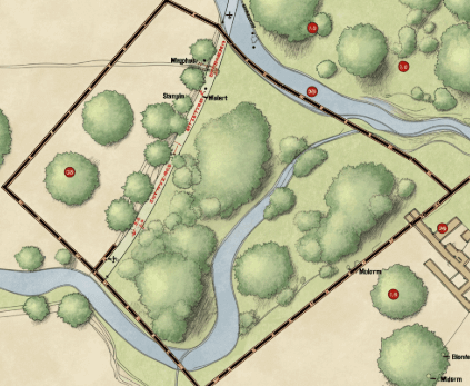
- Definition of Metes and Bounds: Metes and Bounds is a land surveying method that describes property boundaries using natural features like rivers, trees, and rocks. This system creates unique property shapes based on local landscapes rather than uniform grids.
- Origin and Historical Importance: Originating in England, Metes and Bounds were brought to the U.S. during colonial times. They played a key role in early land ownership and were widely used before the adoption of more standardized surveying methods like the rectangular grid.
- How It Works: This system relies on a “point of beginning” and detailed instructions to outline property lines. Each boundary is described using measurements and directions, always returning to the starting point to form a complete loop.
- Challenges of Using Metes and Bounds: Natural landmarks define boundaries and can change over time—trees can be cut down, or rivers can shift course. This makes property disputes more likely and can complicate legal questions about land ownership.
- Relevance to AP Human Geography: Learning about Metes and Bounds helps students understand how geography, law, and history intersect in land use. It demonstrates how natural landscapes influence human activities, such as settlement patterns and property division.
What is Metes and Bounds in AP Human Geography?
Metes and Bounds is a land surveying method that describes property boundaries using natural landmarks, distances, and directions.
This system relies on easily identifiable features like rivers, trees, or rocks to mark the edges of the land.
Historically, it was widely used in England and became common in early American colonies.
Over time, it shaped how people understood and divided land, making it an important part of property ownership and legal records.
One key aspect is its flexibility, allowing landowners to identify irregularly shaped plots uniquely.
However, it can also lead to confusion if landmarks change or disappear over time.
In AP Human Geography, students explore its role in shaping settlement patterns and land use, helping them connect history, geography, and human behavior.
If you’re wondering, “What is Metes and Bounds AP Human Geography?” understanding this system offers valuable insights into how humans work with their environment to define property and manage land use.
Get Started: Get Your Cash Offer Below…
We are direct land buyers. There are no commissions or fees and no obligation whatsoever. Start below by sharing where your property is and where we can send your offer…
How does the Metes and Bounds system define property boundaries?
The Metes and Bounds system defines property boundaries by using natural features, distances, and directions to describe the edges of a piece of land.
For example, a property starts at a big oak tree, goes 100 feet north to a creek, and then 200 feet west to a rock.
This approach relies on landmarks that are easy to spot and measure, making it flexible for irregularly shaped plots of land.
It was especially useful in early settlements where precise maps didn’t exist and land needed to be divided quickly.
However, the system has its challenges. If a landmark, like a tree or a stream, changes over time, it may be hard to determine the boundary.
This can sometimes lead to disputes over who owns what part of the land.
When studying “What is Metes and Bounds AP Human Geography?” learn how these descriptions shaped how people organized land and settled in new regions.
It shows the connection between geography, human activity, and how we use natural features to create lasting property systems.
How do Metes and Bounds differ from the rectangular survey system?
- Method of Measurement: The Metes and Bounds system describes property boundaries using natural landmarks, distances, and directions. On the other hand, the rectangular survey system divides land into squares or rectangles using a grid of longitude and latitude lines.
- Land Shape: Metes and Bounds are ideal for irregularly shaped plots of land because they adapt to natural features. The rectangular survey system creates uniform plots that are consistent in shape, making it easier to map and organize large areas of land.
- Origin and Usage: Metes and Bounds originated in England and were commonly used in the original thirteen American colonies. The rectangular survey system, developed by the U.S. government, is widely used in newer territories across the country.
- Complexity: Metes and Bounds can be more complex because boundaries depend on natural landmarks, which might change or disappear over time. The rectangular survey system is simpler and more systematic because it relies on a fixed grid system.
- Clarity of Ownership: Property descriptions can sometimes cause disputes due to shifting landmarks or unclear measurements with Metes and Bounds. The rectangular survey system reduces disputes by clearly defining property lines with straight, measurable borders.

What challenges come with relying on the Metes and Bounds system?
The Metes and Bounds system faces several challenges when used to define property boundaries.
One major issue is that it relies on natural landmarks, such as trees, rivers, or rocks, which can change or disappear over time.
For example, a tree might die or be cut down, making it hard to identify the original boundary.
This can lead to landowner disputes over who owns which part of the land.
Another challenge is the potential for measurement errors, especially when distances and angles are not recorded accurately.
Irregularly shaped plots can also make it harder to map and compare properties.
Additionally, this system is less useful in areas where natural features are sparse or hard to recognize.
Modern surveying tools have made the process more precise, but older descriptions may confuse.
When studying “What is Metes and Bounds AP Human Geography,” learn how these challenges have impacted property ownership and why other systems, like the rectangular survey system, were developed to address these issues.
How does the Metes and Bounds system affect land ownership disputes?
- Shifting Natural Landmarks: The Metes and Bounds system uses natural features like trees, rocks, or rivers to mark property boundaries. When these landmarks change or disappear over time, it can cause confusion and disputes about who owns specific parts of the land, which brings challenges when exploring “What is Metes and Bounds AP Human Geography.”
- Unclear Measurements: Measurements recorded in the Metes and Bounds system can sometimes be vague or inaccurate. When distances and directions are not clearly defined, it becomes difficult for landowners to determine exact boundaries, leading to ownership disagreements.
- Irregularly Shaped Land: Since the system adapts to natural features, it often results in irregularly shaped plots. These unique shapes can overlap or leave gaps, creating disputes about which portions belong to whom, a problem highlighted when studying “What is Metes and Bounds AP Human Geography.”
- Changes Over Time: Landscapes can evolve over decades due to natural events like floods or human activities like construction. These changes make it harder to identify original boundaries, increasing the likelihood of conflicts between property owners.
- Complex Legal Language: Older Metes and Bounds descriptions often use outdated or difficult-to-understand terms. This can complicate legal processes when resolving disputes, as modern surveyors and owners may interpret the boundaries differently.
What tools are essential for interpreting Metes and Bounds property descriptions?
Several tools are essential for accurately understanding land boundaries when interpreting Metes and Bounds property descriptions.
Surveying equipment, like a compass and measuring tape, helps determine directions and distances based on the description given.
Maps and aerial imagery are also crucial as they visually represent the land and its natural landmarks, such as trees or rivers.
Modern tools like GPS devices and digital mapping software make pinpointing exact locations and tracking changes over time easier.
Historical land records are often needed to verify old property descriptions and identify past landmarks that may no longer exist.
Knowing surveying terms and techniques is important to interpret legal descriptions of property correctly.
When studying “What is Metes and Bounds AP Human Geography,” you’ll discover that understanding the role of these tools helps address the system’s challenges.
Experts like Steve Daria and Joleigh, both seasoned real estate investors and cash land buyers, emphasize the value of precise tools when dealing with properties defined by this method.
If you’re navigating complex land ownership questions, consider reaching out to professionals like Steve and Joleigh for expert advice and solutions!
**NOTICE: Please note that the content presented in this post is intended solely for informational and educational purposes. It should not be construed as legal or financial advice or relied upon as a replacement for consultation with a qualified attorney or CPA. For specific guidance on legal or financial matters, readers are encouraged to seek professional assistance from an attorney, CPA, or other appropriate professional regarding the subject matter.